


Credit: NASA’s Scientific Visualization Studio
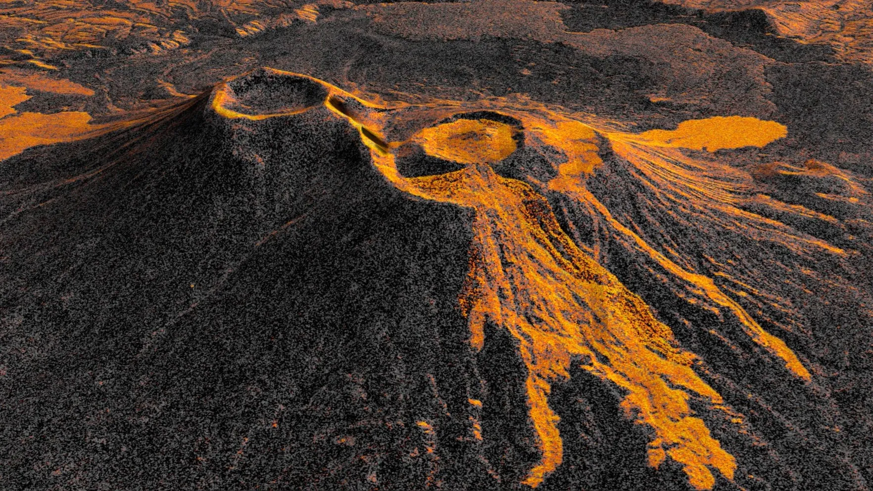
Like tendrils on a vine, lava spreads out from the northern crater of Krasheninnikov, a volcano pair on the Pacific coast of Russia’s Kamchatka Peninsula. On July 30, 2025, an 8.8-magnitude earthquake had struck in the nearby ocean, apparently jolting one of the two volcanoes awake. A few days later, for the first time in nearly five centuries, Krasheninnikov started erupting. Since that day, the northern volcano has been spilling a steady, eastward-flowing field of molten rock and debris, and the NASA-ISRO Synthetic Aperture Radar (NISAR) mission has been tracking the changes in the landscape.
From its vantage point 464 miles (747 kilometers) above the surface, NISAR captured an image of Krasheninnikov on Dec. 25, 2025, just as the Earth-observing satellite was finishing post-launch checks and becoming operational. Twice every 12 days since — once as the satellite passed south to north, and again as it passed north to south — NISAR has returned to the same spot in orbit and taken detailed radar snapshots.
Researchers put 17 of the frames captured through mid-August into sequence, forming a time-lapse video that shows lava filling a smaller, inner caldera, then overflowing into a wider crater before widening into a fan. The animation highlights how NISAR’s observations can monitor the development of natural hazards, both for science and potentially for emergency response.
Though remote, many of Kamchatka’s dozens of volcanoes are closely monitored with ground instruments because they erupt frequently. Not so with Krasheninnikov, which has been quiet since about the year 1550. That NISAR’s L-band radar observed it at all speaks to the satellite’s near-global coverage of the planet’s land surface at resolutions in the dozens of feet; that it captured the erupting volcano over time shows the precision and reliability of its measurements.
“The consistency is crucial. Twice every 12 days, acquiring in this high-resolution mode and in two observation directions, this shows the promise of NISAR to closely monitor natural hazards,” said Matthew Pritchard, a member of the NISAR science team and geophysicist at Cornell University who analyzed the data used to create the animation.
The detail in a single NISAR image results from the use of synthetic aperture radar, or SAR, a specialized processing technique pioneered by NASA’s Jet Propulsion Laboratory in Southern California for Earth observation from space. As the satellite orbits, the radar sends thousands of microwave pulses per second to Earth and receives the return signals, each of which is effectively a snapshot in time that contains information about the properties and characteristics of the surface below.
The SAR processing combines the many images of the same area, sharpening the view just as a lens brings a blurry object into focus. Each pixel in the individual frames of the Krasheninnikov time-lapse represents about a 30-foot-by-30-foot (10-meter-by-10-meter) square on the surface — about half the size of a tennis court.
Lava shows up lighter in the images due to the way that microwaves reflect more brightly compared with the surrounding surface, which, depending on the time of year, is either snow or bare ground. In addition to the lava field growing to the east, the video shows another flow to the northwest, one that likely formed before NISAR captured the first NISAR image.
When Pritchard was doing his doctoral research on Kamchatka volcanoes more than 20 years ago, analysis-ready radar data was difficult to come by, both because satellites didn’t revisit as often and the resolution of the images was relatively low.
Now in addition to getting frequent and comprehensive coverage of virtually all the planet’s roughly 1,300 active, above-sea-level volcanoes, the images are sharp down to the several-meter scale and are easily accessible via the cloud.
“We’re seeing volcanoes around the world that we’ve never really had eyes on like this before,” said Pritchard.
The NISAR satellite is the first free-flying space mission to feature two radar instruments: an L-band system and an S-band system. The systems are complementary due to their differing wavelengths. For example, the longer-wave L-band can pass through tree canopies, imaging the ground beneath. Meanwhile, depending on leaf sizes, S-band can collect observations of those canopies.
The data products from the NISAR mission’s L-band radar are available at the Alaska Satellite Facility Distributed Active Archive Center in Fairbanks, which hosts and distributes all NASA synthetic aperture radar data.
Managed by Caltech for NASA, JPL leads the United States component of the project and provided the satellite’s L-band SAR and antenna reflector. The spacecraft bus and its S-band SAR were provided by ISRO (Indian Space Research Organisation).
The NISAR satellite is the first to carry two SAR instruments at different wavelengths, collecting data using the spacecraft’s giant drum-shaped reflector, which measures 39 feet (12 meters) wide, which is the largest radar antenna reflector NASA has sent into space.
To learn more about NISAR, visit:
https://science.nasa.gov/mission/nisar/
Media Contacts
Andrew Wang / Andrew Good
Jet Propulsion Laboratory, Pasadena, Calif.
626-379-6874 / 818-393-2433
andrew.wang@jpl.nasa.gov / andrew.c.good@jpl.nasa.gov
2026-064
