


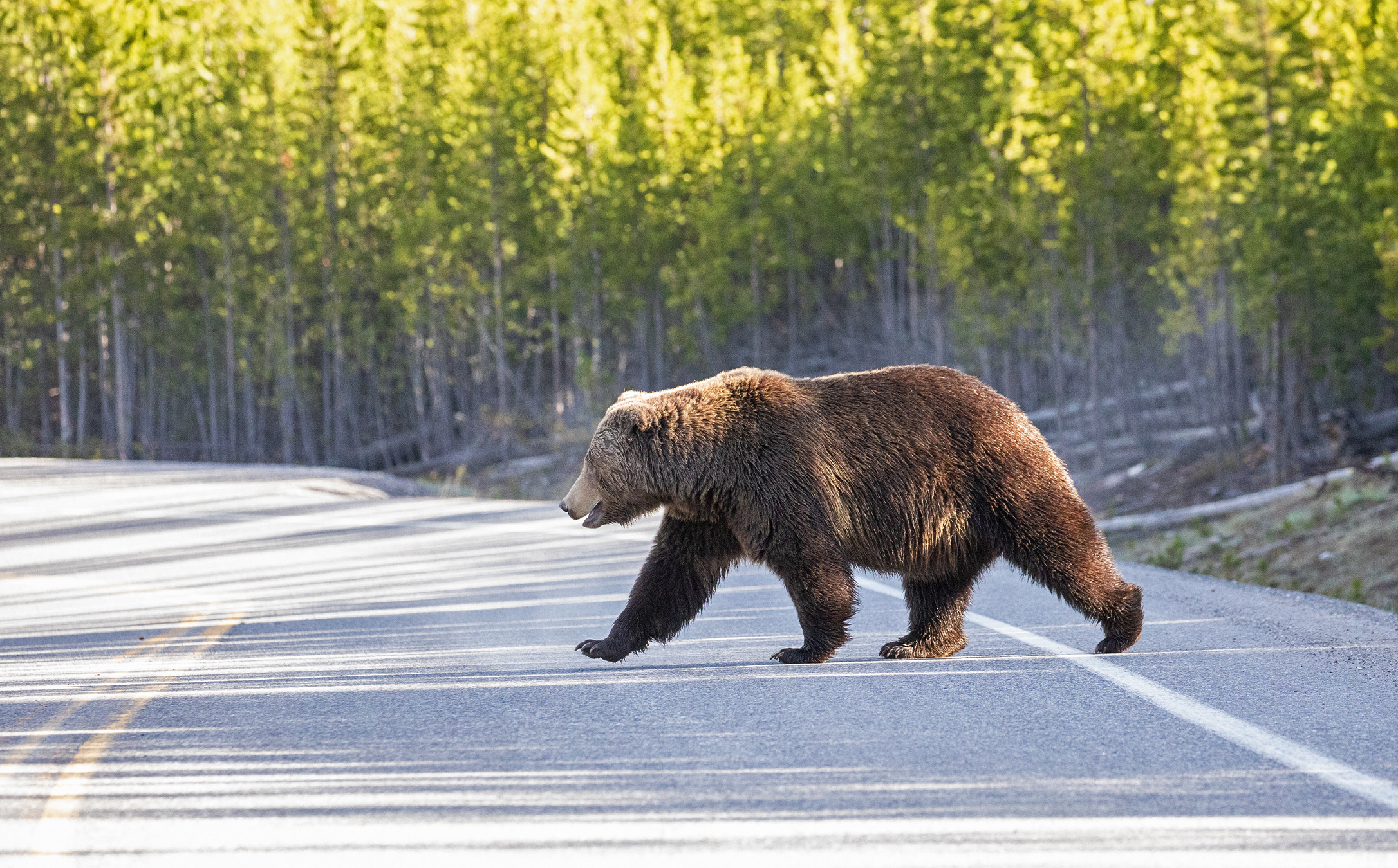
- Across the world, roads, railways, towns and farms sever habitat, preventing wildlife from moving across the landscape. Cutting off animals’ ability to connect can limit genetic exchange and cause entire populations to decline — and ultimately, collapse.
- The Yellowstone to Yukon Conservation Initiative, or Y2Y, is trying to create a giant connected area stretching across the Rocky Mountains from the Greater Yellowstone ecosystem in the U.S. to Canada’s Yukon Territory. It will allow animals to move, meet and mate.
- Across Canada, the U.S. and the world, countries are building wildlife crossings that reconnect habitat and keep motorists safe from costly, potentially deadly collisions with animals.
BRITISH COLUMBIA, Canada — On a sunny Thursday in May, Kent Kebe had to scrape yet another bighorn sheep carcass off Highway 93/95 running through Radium, British Columbia. The necropsy confirmed what Kebe, the village’s protective service manager, already knew: A car collision killed the ram.
Roadkill deaths hit this community hard. Residents love their sheep so much that the village center sports a huge steel sculpture of sheep horns that stands roughly 12-meters- (39-foot-) wide and 6-meters- (19-feet-) tall. The Big Horn Cafe on the main drag features artwork of bighorn rams and serves custom-blended “Headbanger tea.”
In the 1990s, about 350 bighorn sheep (Ovis canadensis) milled around, drawn to the golf course and the grasses along the highway. “It’s like a candy store for them,” Kebe says. But by 2022, the herd’s numbers had dwindled to 140. While some sheep died from natural causes, vehicle collisions played a big role in the death toll.
“There’s a tension where the sheep are the mascots of the village, but the traffic is killing them,” says wildlife scientist Clayton Lamb, who works with the nonprofit Biodiversity Pathways and the University of British Columbia. He helped bring attention to the issue in 2022.
Habitat loss is a major threat to species, but highways, railways and towns impact how animals move to eat, meet and mate — and that can endanger their survival. A 2025 review in the journal Science warned that while the world aims to protect 30% of the planet by 2030 under the U.N. Global Biodiversity Framework, isolated areas will become “genetic dead ends” if they remain disconnected.
“Habitat is great, but if it’s an island and not connected to other habitats, it can result in local species dying off,” says Tim Johnson, the landscape connectivity specialist with the nonprofit Yellowstone to Yukon Conservation Initiative (Y2Y).
Reconnecting the landscape
Early efforts to link habitats began decades ago, and sometimes all it took was a single animal corridor — an overpass, underpass or a protected strip of land — to build a pathway from one safe haven to another.
But the conservation world is now prioritizing connectivity, recognizing the critical need to reconnect continuous stretches of the landscape, rivers, flyways and marine corridors. This is what it takes to help entire ecosystems thrive, Johnson says.
Y2Y, launched in 1997, was among early pioneers of landscape-scale conservation with an ambitious vision: To create one giant connected area that stretches from the Greater Yellowstone ecosystem in the U.S. northwards to Canada’s Yukon Territory.
“If we don’t get it right there, then we’ve lost the most intact, connected, wild, large mountain region in the world,” says Jodi Hilty, Y2Y’s president and chief scientist. The initiative has already protected more than 9.8 million hectares (24 million acres) of habitat, linking corridors, and has supported construction of some 204 wildlife crossings.
But what does it take to build a “corridor” that stretches 3,400 kilometers (2,100 miles) and spans five U.S. states, two Canadian provinces and at least 75 Indigenous territories?
It requires a mosaic of projects that range in scale and approaches, Hilty says, taking a “hearts and lands” approach. It’s a question of building connections between different partners, learning from centuries of Indigenous stewardship — and using science to inform decisions that work for both wildlife and humans.
And most of all it requires learning about what’s needed, what works and sometimes, what doesn’t.


A deadly choke point
Driving along Highway 3, which crosses the Rocky Mountains in southern British Columbia and Alberta, wildlife biologist Clayton Lamb points out a familiar sight: An abandoned vehicle with a crumpled hood, smashed windshield and shattered headlights. Tufts of elk (Cervus canadensis) fur stick out from the windshield wipers.
To secure the Y2Y vision, it’s important to look to where the corridor is most threatened, Hilty says, and that includes a stretch of Highway 3 from Hosmer, B.C., to Rock Creek in Alberta.
It slices through a narrow section of the Rockies where the animals are funneled into a tight corridor of survival, just 70 km (43 mi) wide. More than 300 collisions between vehicles and large mammals occur here each year, and the animal death toll is so high that two large morgues are stationed along the section for the battered carcasses. “The highway is like a predator that never sleeps,” Lamb says.
It’s not just a problem of roadkill. The mere presence of the road and the noise of traffic can deter animals from nearing it, creating an obstacle to their movement, Lamb says.
He’s put GPS collars on grizzly bears (Ursus arctos horribilis), elk, deer and bighorn sheep — and tracked their behavior with collaborators from the B.C. government and colleagues from Alberta. The data they gathered revealed dozens of kilometers of highway where the elk simply won’t cross.
For those that do attempt to cross, the consequences can be dire. The road cuts through Elk Valley, which provides ideal habitat for many species including the grizzly bears that thrive on spring vegetation and berries and an abundance of elk and mule deer (Odocoileus hemionus). But vehicle collisions, along with human-bear conflict, kill 5 – 8% of these grizzlies each year according to research published in 2020 in the Proceedings of the National Academy of Sciences. The population only remains stable thanks to immigrant bears that move into the valley.
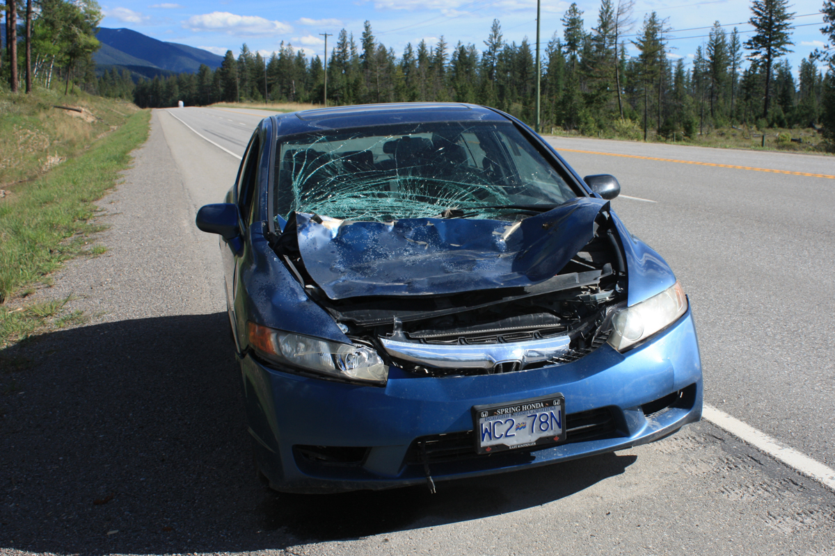
While all roads deter wildlife movement to some degree, the threats posed by Highway 3 are particularly severe because the geography allows such a small passageway. “If we cut the Rockies in half at Highway 3, then we lose the Y2Y vision,” Hilty says.
Recognizing the critical nature of this pinch point, the nonprofit Miistakis Institute launched a citizen science project in 2004 to get a clearer picture of the road’s impacts. Both community volunteers and commuters driving along the Alberta mountainous section of the highway logged animal sightings and roadkill on a web app.
When the researchers overlayed this information with government crash data, they identified hotspots where the highway was failing both people and wildlife, says Tracy Lee, Miistakis director of conservation research.
Reconnect the landscape
Researchers continued to collate data on the patterns of wildlife behavior and collisions in B.C. and Alberta, and, in 2020, a broad coalition launched the Reconnecting the Rockies project: conservation groups, Indigenous nations and the B.C. Ministry of Transportation and Transit, as well as industry partners like Teck Coal (now Elk Valley Resources). Its mission is to reduce wildlife-vehicle collisions and restore connectivity on Highway 3 by engineering a system of wildlife crossings — underpasses, overpasses, retrofitted bridges and fencing — on the 80 km (50 mi) between Lundbreck, Alberta, and Hosmer, B.C.
The highway is a huge threat to wildlife, but the problem is solvable, Lee says. The solution lies in collecting data on animal movement, engineering the landscape to create safe passage across the roads — and local stewardship.
“It’s about shifting our perspective from seeing roads as permanent lines of division, to seeing them as places where a working human landscape can gracefully bend to let the natural world pass through,” she says.
Since 2020, Reconnecting the Rockies has retrofitted and constructed underpasses in both provinces; Alberta has announced plans for 20 more crossing structures. Although the project is only 17% complete, wildlife-vehicle collisions have already dropped substantially, with no collisions at all in some fenced sections. Cameras installed nearby have documented thousands of elk, deer, grizzly and black bear crossings.
On the B.C. side, the 2020-2030 construction costs are estimated at around $50 million CAD ($35 million USD) for fencing, retrofitting bridges and building an overpass and two underpasses.
But each collision involving an elk or moose carries a high price tag, costing an estimated $70,000 in medical care, property damage, vehicle repair and carcass cleanup. Some 200 large mammal collisions occur on Highway 3 each year between Hosmer, B.C. and the Alberta border, costing $2.8 million CAD ($2 million USD) each year. Experts say the system of crossings should pay for themselves within 20 years.
“We are paying more to run over animals than we would be to just solve these issues,” Lamb says, which would keep people and wildlife safe. “It’s a no-brainer.”

Navigating humans
Helping wildlife cross the highway is only half of the solution, Lamb says. The other half is ensuring they can navigate the terrain on both sides. “We don’t want to just build an overpass to nowhere,” he says.
A typical wildlife crossing in Banff National Park — which has 44 crossing structures along the Trans-Canada Highway — offers safe passage from one stretch of land to another, both sides owned by the Canadian government. But it’s a different story outside the parks system. Wildlife often navigate valley bottoms to move between wilderness areas, but these low-elevation basins are precisely where humans settle.
Elk Valley — a critical region for the Y2Y vision — is no exception. It’s sliced by roadways and recreational trails, dotted with towns, farms, coal mines, logging operations and other development that all lay claim to the same land that wildlife need to feed in and move through.
“To be direct, this is where wildlife meets human life,” says Kevin LaRoche, director of the Elk Valley Land Trust (the Trust).
Researchers call these areas where humans live, work and recreate “working landscapes.” Figuring out how to sustain connectivity through this complex patchwork of human footprints is key to the Y2Y vision. Instead of simply building an overpass or underpass and considering the job done, conservationists need to navigate complex territory.
“All these things happen in a working landscape that make it more complicated,” Lamb says, offering an example: “How do you thread the needle through these six subdivisions that are proposed in the key corridor? And what if there is a campsite or trail there?”

The goal becomes establishing a permeable landscape matrix where both human communities and wild species can coexist, and Elk Valley is the ultimate testing ground for how to make this work: It’s a corridor for elk, wolves (Canis lupus), grizzly bears and lynx (Lynx canadensis), among other species.
The coal mining town of Fernie lies at the heart of this corridor. It’s a hotspot for recreation and its population is growing rapidly as people flock in for its skiing, hiking and biking trails. Sprawling human infrastructure is creating an “urban dam” — a choke point for animal movement — and housing developments are now moving upslope.
“That can completely sever the last remaining bypass lane for a grizzly bear or an elk herd trying to move through the Elk Valley,” LaRoche says.
The Trust has proposed a 7.5-km- (4.7 mi-) long corridor on the valley’s western slope to maintain connectivity, which is gaining financial support.
Neither decisionmakers nor environmental funders are writing checks for isolated parks anymore, LaRoche says. “They are writing checks for functional corridors. They want to know that the piece of ground they are helping to buy is going to act as a lifeline that keeps the broader ecosystem from suffocating.”
Planning for the corridor is moving forward in concert with municipal, regional, provincial and First Nations authorities.
Trying to maintain connectivity in a working landscape is no easy undertaking, LaRoche says. “It takes time. It takes good faith. And it takes luck.”

It takes a village
Back in Radium, efforts focus on how bighorn sheep can cross Highway 95 — which is also known as the Radium Hill Highway — without getting killed. Alarmed by the declining number of sheep, the community first contacted the province’s Ministry of Transportation and Transit and Ministry of Water, Land and Resource Stewardship in 1990. Wildlife crossing signs went up, along with flashing warning signs, and a Facebook page, “Help the Radium Bighorn herd,” came online.
“People had to come together and find a solution that would help those animals live amongst this now urbanized landscape,” Lamb says.
Then, in 2021, a detour rerouted Trans-Canada Highway traffic through Radium. Collisions killed 19 sheep and the community’s efforts took on a new urgency. Historically, the sheep migrated through British Columbia’s Shuswap lands that are culturally and spiritually important to the Shuswap Band (Kenpesq’t) of Secwépemc First Nation, so they have taken the lead in protecting the sheep.
“We’re encroaching on their land. It’s not them encroaching on our land,” says Shuswap sheep monitor Pam Martin. “And as the Shuswap people, our responsibility is to care for them and the environment.”
In 2022, they established the Shuswap Band Guardians program. Martin and another trained monitor began daily highway patrols to warn drivers when sheep are on the road. They also keep tabs on the herd’s health and behavior.
Between 2023 and 2024, roadkill deaths dropped to six a year. Still, the community pushed for a more comprehensive solution, and in 2024, the B.C. transportation agency agreed to fund and construct a $15 million CAD ($10.7 million USD) overpass on a busy stretch of Highway 95 near Radium.

A group of local officials, including Richard Martin, a councilor for the Shuswap Band, conducted the ribbon-cutting ceremony on June 2, 2026.
Some sheep, unaware that the overpass was not yet officially open, had already been using it.
Lamb, working with the Shuswap Band, captured and collared 17 bighorn sheep to help biologists and the Indigenous guardians see how the sheep will use the overpass in the coming years.
“It is not a case of, ‘if you build it, they will come,’” Pam Martin says. By May 2026, Martin had only seen one ewe use the overpass, although the rams appear to enjoy sitting on it and sedately viewing the roaring traffic below.
Drawing from knowledge gleaned from 12-hour days watching the sheep, month in, month out, she believes it will take time for them to adapt to the overpass, and the guardian will play an important role in helping steer them to use it. She has built trust and familiarity with the sheep in the last few years: She speaks to them in Shuswap, and they know her truck and the sound of her voice.
“I know my sheep. I know what is going on,” Martin says. “Personally, I think it will take close to three or maybe five years for them to fully functionally use it.”

‘Hearts and lands’
The Radium overpass now belongs to a system of more than 204 crossings, underpasses and fencing structures that protect wildlife and drivers on highways in the Y2Y region.
A massive continental corridor like the Y2Y vision is not a single, giant swath of untouched wilderness: It’s a mosaic of fragmented lands and protected parks. Corridors only function, if micro-choke points are fixed.
It’s ironic, LaRoche says, that Y2Y “is about connecting wildlife populations over hundreds or thousands of kilometers, but all connectivity projects are local.”
The Columbia River Valley is a critical north-south movement corridor, and the Radium overpass will provide safe passage for everything from badgers, black bears (Ursus americanus), cougars (Puma concolor) and deer to elk and bighorn sheep. Although it’s only a single overpass, the project illustrates a vital component of building connectivity: It takes people who care.
The Miistakis Institute’s Highway 3 Road Watch project had a surprising outcome, not from collision data, but from the social investment the project built, Lee says.
Previously, locals and commuters often considered road mitigation an expensive government imposition. But by engaging truck drivers, local citizens and council members in data collection, the project created a dedicated community.
“Suddenly, the conversation shifted from ‘Why is the government spending money on wildlife?’ to ‘When is the government going to fix our highway to keep us and the animals safe?’” Lee says.
These projects need buy-in, participation and public support. In Radium, local knowledge of the sheep’s behavior and Indigenous guardianship has also played a big role in bringing the project to life, Johnson says.

Hilty says she believes that recognizing First Nations’ rights and braiding traditional knowledge with science is essential to achieving the success and durability of the Y2Y vision. The ultimate goal is to ensure that both cultural and ecological pathways flourish into the future, she says.
As such, building connectivity requires more than engineering structures. Informed by science, it’s an art: Balancing the needs of both humans and wildlife while accepting imperfect solutions and compromises.
Sheep are still being killed on Radium’s busy highway — the overpass only works for the section of the road it was built on. “It’s absolutely not a silver bullet,” Kebe says.
Despite all the measures taken, some sheep will always get hit on the highway, Kebe says, because they live in a human environment.
Though he’s still scraping dead sheep off the highway, he’s optimistic about the herd’s future. The early season count of sheep and pregnant ewes hints that the population could be as high as 150 this year, an improvement over previous years.
It’s going to take a multi-pronged approach to protect the sheep, Kebe says. The residents need to work with the ministries, monitor tourists and watch out for red flags and quickly deal with them, he says. “We just need to look after our sheep,” Kebe says. “And that takes a community.”
Banner image: For some animals, roadways act like fences: They don’t even attempt to cross. Others, like bears, moose, bighorn sheep and some smaller species, may attempt to cross, though it can prove deadly. Image courtesy of the National Parks Service of Canada.
Reporting and travel for this story was supported by the Sitka Foundation and the Science Media Centre of Canada.
The long and winding road to safe highways: Inside the global movement to reconnect habitat
Above an Australian highway, a bridge reconnects wilderness for quolls, koalas and other animals
Wildlife’s unpredictable movements make climate-change planning difficult
Citations:
Hilty, J. A., Chester, C. C., Wright, P. A., & Zenkewich, K. (2024). Uniting hearts and lands: Advancing conservation and restoration across the Yellowstone to Yukon region. Frontiers in Conservation Science, 4. doi:10.3389/fcosc.2023.1264460
Lee, T., Quinn, M. S., & Duke, D. (2006). Citizen, science, highways, and wildlife: Using a web-based GIS to engage citizens in collecting wildlife information. Ecology and Society, 11(1). doi:10.5751/es-01681-110111
Lamb, C. T., Ford, A. T., McLellan, B. N., Proctor, M. F., Mowat, G., Ciarniello, L., Nielsen, S. E., & Boutin, S. (2020). The ecology of human–carnivore coexistence. Proceedings of the National Academy of Sciences, 117(30), 17876-17883. doi:10.1073/pnas.1922097117
FEEDBACK: Use this form to send a message to the author or editor of this post. If you’d like to post a public comment, you can do so at the bottom of the page.
