


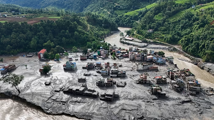
The giant flash flood that tore through settlements near Nepal’s border with China on Wednesday came as a brutal reminder of the growing risks to people in the Himalayas, a mountain range scientists say is deeply vulnerable to climate change.
It is too early to establish definitively what caused Wednesday’s flood, but scientists said satellite imagery before and after the disaster suggested that a large portion of cliff north of the Langtang Lirung mountain close to Tibet collapsed, snapping off a huge chunk of glacier sitting over it.
The force of tens of millions of cubic metres of falling rock and ice was initially mistaken for an earthquake and, by some estimates, unleashed enough energy to melt the glacial ice, sending an enormous wall of rock, mud and water cascading dozens of miles down the Bhote Koshi valley into Nepal.
The calamity highlighted the dangers posed by glaciers and mountain slopes increasingly impacted by climate change in an area scientists say is warming more quickly than the global average and where some worry that vast Chinese hydroelectric projects could be adding to the risk of disaster.
More than 390 people have been confirmed killed by Wednesday’s flood, with more than 1,400 missing on Thursday evening.
Kristen Cook, a geomorphologist at the University of Grenoble, said analysis on Thursday of fresh satellite images suggested that a large section of cliff under the glacier at Langtang Lirung had collapsed.
While rock avalanches were not unusual in the high Himalayas, “the unusual thing about this event and why it was such a disaster is that it’s extremely large”, she said.
“The lower part of the hanging terminus of the glacier seems to have fallen off and cascaded about 1,300 metres into the valley below,” said Simon Cook, an environmental scientist at the UK’s University of Dundee.
Simon Allen, a disaster risk researcher at the University of Zurich, said it was clear from the satellite images that “a large mass of rock and ice had failed” and fallen as an “ice-rock avalanche” that caused the devastating flood.
Allen said researchers in the Glacier and Permafrost Hazards in Mountains working group had not yet worked out the size of the fall, but based on the seismic signature, they calculated that 50mn-100mn cubic metres of debris would have hit the ground.
“It’s massive,” he said. “It’s bigger than any event of this type that we’ve seen in the region, at least in historical times.”
“What I saw looked like a hurricane of water; our house was lifted several metres into the air and then collapsed,” said Giri Lal Budhathoki, 38, a truck driver who lives downstream in Nepal’s Rasuwa district.
Budhathoki, who narrowly survived the flood and was flown to a Kathmandu hospital with head and arm injuries, said he was readying himself to mourn his wife and four children, who were still unaccounted for.
The US Geological Survey initially reported a 4.4 magnitude earthquake in an area close to the border between Nepal and China, but later revised this to a 5.2 magnitude landslide, saying the seismic energy was “generated by a glacial collapse and debris flow”.
Anil Kulkarni, a glacier expert at the Indian Institute of Science in Bengaluru, said glaciers in the Himalayas were retreating “very fast”.
“Because now the Himalayan region is warming . . . at a much higher rate than the global mean, the permafrost between the ice mass and the rock has started to weaken,” Kulkarni said.
A similar though smaller disaster occurred in Rishi Ganga valley in India in 2021, he added, when a large mass of rock, snow and ice fell from a mountain into a valley, causing the deaths of over 200 people.
Kulkarni said the 2021 disaster had underlined to the scientific community just how destructive a glacier fall could be. “And remember, there will be thousands of such hanging glaciers in the mountains. So it is really tricky to know how to handle it,” he said.

The World Bank and Asian Development Bank have warned that Nepal’s varied topography and social vulnerability make the country particularly susceptible to geological and climate-related disasters and to floods caused by glacier-lake outbursts or heavy rain.
“Climate change is already having significant impacts on the environment in Nepal . . . glaciers are melting, and the frequency of precipitation extremes is increasing,” they said in a 2021 report.
Kulkarni said hydroelectric dam construction and increasing development in the Himalayas were increasing the vulnerability of countries in the region to glacier collapses. Resulting big surges of water can burst dams and expose growing river-valley populations to flooding.
“We are experiencing disasters on a scale and of a nature which we never experienced in the past,” he said.
Cook at Dundee university said early warning systems could help, but spotting glaciers that might collapse was like “looking for a needle in a haystack”.
“They look like any other glaciers quite often and it’s quite difficult to predict which ones are dangerous,” he said.

Some experts are concerned about China’s extensive dam-building programme in Tibet, particularly its plans for what will be the world’s biggest hydroelectric scheme on Yarlung Tsangpo, which flows into India where it is known as the Brahmaputra.
Premier Li Qiang, China’s second-ranked leader — who was dispatched by President Xi Jinping on Thursday to oversee relief work in the Gyirong area which was hard hit by this week’s flood — attended a groundbreaking ceremony for the dam scheme in south-eastern Tibet last year.
Chinese officials have dismissed concerns about the mega-dam’s environmental impact or potential effect on downstream supplies of water.
The complex plan for the project involves harnessing a 2,000-metre drop over 50km in a bend in the Yarlung Tsangpo by diverting the water through tunnels — an undertaking expected to create huge amounts of debris and that will involve drilling through complex geological formations.
“Human-induced infrastructural development can also contribute to seismic risks,” said Jagannath Panda, head of the Stockholm Center for South Asian and Indo-Pacific Affairs.
Panda said the mega-dam project, “in terms of both its volume and scale”, had the potential to contribute to greater seismic risks, potentially increasing the chance of landslides.
“This is certainly one project that China should review carefully, with much greater transparency, disclosure and dialogue with Himalayan countries, particularly India, Nepal and others,” Panda said. “Hopefully, this disaster will create the necessary awareness in China about the importance of discussing these issues more openly with India and other lower-riparian countries.”
Cartography by Steven Bernard, Jana Tauschinski and Aditi Bhandari

