


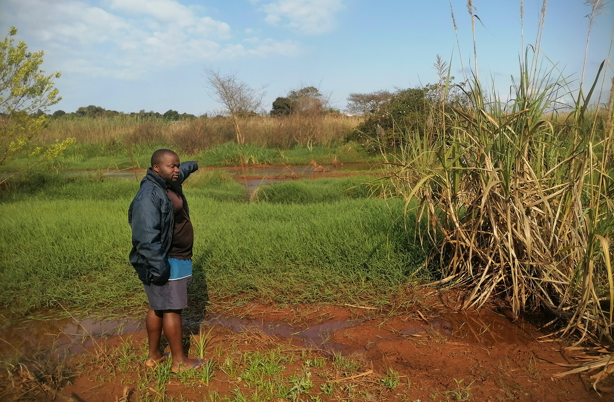
- Tshakhuma in South Africa’s Limpopo province was ravaged by January floods, killing people and disrupting livelihoods.
- Community members say blocked drainages and overgrown river courses exacerbate the problem amid fears of future disasters.
- Residents are finding their own ways to respond, including the use of WhatsApp to warn neighbors of potential flooding.
- The Limpopo government and Makhado municipality have intensified public awareness campaigns in the area, but community members say communication alone is not enough.
TSHAKHUMA, South Africa — Divhani Rashaka moved up and down the yard of the homestead he has looked after for 26 years, looking toward the Tshamugwana River. He recounted experiencing several floods in the time he has lived here.
The riverbed, a few meters from his house in the Tshakhuma area of Limpopo province in the north of South Africa, is now covered with tall grass and bushes. Channels carved into the ground during the January floods show where water found its way toward the house.
Rashaka, who is a resident of Tshiswiswini village, has placed stones along some of the channels in an effort to slow or redirect the water if heavy rains return.
Farther up the yard, between his house and his neighbor’s, the grass had also grown thick, but Rashaka and his neighbor cleared the area to allow water to pass through more easily.
Beyond these small measures, Rashaka has no formal plan for protecting his homestead, should it flood again. In January, floods affected communities across Limpopo, killing people, damaging homes and infrastructure, washing away food and disrupting schooling and access to some areas. Tshakhuma was among the communities badly affected.
During these floods, 21 families whose homes were badly damaged were relocated to temporary accommodation at a lodge in Nkuna village, about 20 kilometers (12 miles) away, while temporary residential units were being prepared.
If another flood comes, Rashaka said, he will have to rely on those around him. “I can seek shelter from my neighbors,” he said.
His situation reflects a wider concern in Tshakhuma, where residents said they have been left to prepare for future floods by themselves while waiting for authorities to address some of the problems they say contributed to the January flooding.
President Cyril Ramaphosa and Limpopo Premier Phophi Ramathuba visited Tshakhuma in January to assess the damage.
When Mongabay visited the area in September, residents were still pointing to riverbeds, bridges and drainage routes that they said needed attention before the next heavy rains.
Some residents said they had experienced flooding for several years and had few options when rivers overflowed. “We have some solutions, but we do not have the financial resources and some technical skills to mitigate the effects of floods,” said Thama Mutheiwana, a community leader.
In Ward 29, an administrative and residential ward in Tshakhuma, Mutheiwana walked Mongabay to the Lutanandwa River, where the riverbed was covered with sand, bushes and grass. “This is not the normal river flow course. During the floods, water made its own way, leaving the normal course because the riverbed has overgrown grass and bushes,” Mutheiwana said, pointing to a waterway formed during the January floods.
According to Mutheiwana, building a stone wall along the riverbed and cutting all overgrown bushes and grass could reduce flood impact.
Similarly, in neighboring Ward 28, residents said the Tshamugwena River had become overgrown with bushes and grass.
According to Joel Mulaudzi, a resident of Tshiswiswini whose house is a couple of meters from the river, the bridges in the area are too narrow. “We believe if the government widens the bridge, water will flow in its normal way,” he said.
While residents wait for the improvement of infrastructure and other interventions, they have also started relying on one another to prepare for floods.
Community members use a WhatsApp group to warn one another when heavy rain is expected or when rivers and roads become dangerous. Mutheiwana and Mulaudzi initially formed the group to update community members about service delivery issues and provide notices of funerals, but following sustained flooding in the area, the group has since been repurposed to include warnings about possible flooding.
The group provides a way for residents to share information quickly, particularly about water levels, flooded routes and areas that should be avoided.
For people living close to rivers, such warnings can provide crucial time to move children, livestock and household belongings to safer places.
But residents said communication alone cannot solve the physical problems they face.
According to Tsakani Baloyi, the spokesperson for the Department of Cooperative Governance, Human Settlements and Traditional Affairs in South Africa (COGHSTA), the department has prioritized vulnerable areas including Tshakhuma and intensified public awareness campaigns to alert the community about possible disaster risk, including flooding.
“Once the PDMC [Provincial Disaster Management Centre] receives Impact Based Weather Forecast from the South African Weather Services, the information is quickly conveyed to all the identified flood hotspots (vulnerable areas) through social media and other platforms,” she said in an email.

Communities often have detailed knowledge of where floodwater moves because they have experienced repeated flooding, Ephias Mugari, a disaster-risk researcher with the University of Limpopo, told Mongabay.
He said this knowledge should form part of formal flood-risk assessments rather than be treated simply as anecdotal information.
“Communities can identify risk accurately but rarely have the machinery, budget or legal mandate to act on stormwater or drainage infrastructure themselves,” Mugari said.
He said the responsibility therefore lies with municipalities to ensure that risks identified by communities are recorded, assessed and addressed before the rainy season.
For communities such as Tshakhuma, this could mean identifying blocked drainage channels, damaged bridges and other flood-risk points before heavy rains arrive.
Mugari said clearing debris and vegetation from drainage lines and culverts, identifying obstructions to water flow, maintaining stormwater infrastructure and ensuring that early-warning information reaches flood-prone households are among the measures that can reduce risk.
He also warned that waiting until heavy rain arrives leaves authorities with fewer options.
“Once the rain is falling, the only available responses are emergency and reactive,” he said.
Research published in June also highlights the vulnerability of Tshakhuma. The study assessing flood-risk adaptation in Vhembe district in northern Limpopo found that Tshakhuma is in a low-lying floodplain near the Luvuvhu River and experiences recurrent flooding during the summer rainfall season between October and March.
The researchers identified 789 flood-prone homesteads in Tshakhuma. Their survey of 65 households in the village found that structural damage, loss of belongings and food and water shortages were among the effects reported by residents. While the researchers cautioned that their sample was not statistically representative of the whole village, they said it provided insight into the experiences of households in a known flood-prone section.
The study also found that residents had experienced repeated major floods, with respondents recalling at least four significant floods since 2015. Notable of these was in 2021 when Cyclone Eloise caused flooding in Tshakhuma, damaging homes, maize fields, possessions and a brickmaking business. In one section of Tshakhuma, residents reported that floodwaters had reached waist height during the 2021 floods. Furthermore, in 2023, heavy rains again affected Tshakhuma, damaging roads and bridges and rendering some roads impassable.
Meanwhile, residents continue to seek ways of mitigating floods’ impact but lack the financial capacity. South Africa has a national system for managing floods and other climate-related disasters, with responsibilities shared between national, provincial and municipal authorities. The Disaster Management Act requires the government to assess and map disaster risks, identify vulnerable communities, prepare disaster-management plans, develop early-warning mechanisms and invest in disaster-risk reduction and climate-change adaptation.
In addition, the Climate Change Act of 2024 further requires the government to develop adaptation measures based on climate risks and vulnerabilities, including climate monitoring and early-warning systems, while promoting more climate-resilient communities and infrastructure. In 2026, national disaster-management discussions have also identified stronger early-warning systems, climate-resilient infrastructure, emergency planning and community preparedness as priorities.
Until COGHSTA addresses the infrastructural issues facing drainage, bridges and riverbeds, Tshakhuma residents will continue to remain vulnerable to future floods. The department says it has sought municipal intervention and disaster funding to repair damaged infrastructure. But as Mugari’s research highlights, communities need proactive flood prevention and preparedness, not just action after disaster strikes.
Banner image: Thama Mutheiwana, one of the Tshakhuma community leaders, pointing at the overgrown bushes blocking the way for smooth water flow during floods. He suggests that Limpopo disaster management should build a rock barrier wall along the river to slow the flow of water and reduce erosion. Image by Bernard Chiguvare.
Farmers in South Africa’s Limpopo face unpredictable rainfall, uncertain futures
Like ‘climbing Kilimanjaro’ without help: Interview with a Limpopo conservationist
Citations:
Pfarelo, N., Mugari, E., Nethengwe, N. S., & Gumbo, A. D. (2026). Assessing flood risk adaptation actions and plans in Vhembe district municipality, South Africa. African Geographical Review, 1-19. doi:10.1080/19376812.2026.2676550
Cite this article
Bernard Chiguvare (2026). Residents of South Africa’s Limpopo province hold breath amid fears of repeat floods. Mongabay Conservation news. DOI: https://doi.org/10.66709/news-332612

