


- A new data platform is helping scientists understand the extent of protected land worldwide; it also aims to serve as a watchdog for conservation initiatives.
- Global Safety Net v3 (GSN3) uses satellite data, artificial intelligence technology, and mapping techniques to see how landscapes are faring, and if conservation is working.
- Data on how ecosystems around the world are faring are crucial, especially in the face of a global agreement that aims to protect 30% of the world’s lands and oceans by 2030.
Where are ecosystems still left standing? Where should conservation be focused?
A new tool is attempting to answer these questions and serve as a watchdog for conservation and land protection initiatives around the world. Global Safety Net v3 (GSN3) is a geospatial data platform that uses satellite imagery, artificial intelligence, and mapping techniques to understand the extent of landscapes around the world, and how they’re faring.
“We’re interested in how much nature is left, and how well cared for and conserved it is,” Karl Burkart, director of the GSN3 initiative at the Nature Data Lab, a U.S.-based research organization, told Mongabay in a video interview.
At the 2022 summit of the U.N. Convention on Biological Diversity (CBD), 196 countries from around the world adopted the Kunming-Montreal Global Biodiversity Framework. The highlight of the agreement was the “30×30” goal: to protect 30% of the world’s lands and oceans by 2030. Against the backdrop of this agreement, it’s become crucial for conservation scientists and organizations to keep track of how countries are faring and if designated protected areas are indeed based on scientific and conservation priorities.
“We want to make sure that the 30% is the land that’s most critical for ecosystems, that’s essential for communities and livelihoods, and also for biodiversity,” Burkart said.
Karl Burkart spoke with Mongabay’s Abhishyant Kidangoor about how GSN3 came to be, what kind of data the tool displays, and the big surprises unearthed by the data. The following interview has been lightly edited for length and clarity.
Mongabay: How would you describe Global Safety Net to someone who hasn’t heard about it?
Karl Burkart: The simplest way to describe it is that we’re a global observatory of natural land. We are attempting to document the extent of natural land across several ecological functional types and the extent to which land that is important for biodiversity and ecosystems is protected and conserved. We’re just interested in how much nature is left. And how well cared for and conserved it is.
Mongabay: What was the motivation behind doing this? What gaps were you trying to fill?
Karl Burkart: There are very interesting attempts to try and get a global-scale picture of land that’s important, particularly for the U.N. Biodiversity Convention, which was agreed to at the end of 2022. It had this 30×30 target and that brought a lot of scientists together to publish literature on this. So then the question is: 30% — great; but which 30% are you protecting? We wanted to make sure that that 30% is the land that’s most critical for ecosystems, essential for communities, livelihoods, and biodiversity.
Mongabay: Could you walk me through the journey of building this tool?
Karl Burkart: This is called GSN3 because this is version three, but it has been quite an evolution. Now, it’s sort of like “three” as in three-dimensional.
I was working at the Leonardo DiCaprio Foundation when we saw that the biodiversity convention was coming up. But the convention didn’t have a North Star, like how the climate convention had 1.5°C. So we brought a lot of scientists together and published what turned out to be a very important paper called the “Global Deal for Nature,” and that introduced this idea of documenting the extent of land that’s ecologically important and understanding what percentage of that is protected. That paper became foundational to proposals for 30%.
The following year, we put out Global Safety Net, which was GSN1, which was the spatial expression of that concept. It compiled 13 publications and peer-reviewed papers on various types of land that were important for various functions. We assembled them, deduplicated the layers, and created the Global Safety Net. At the time, 50.3% of the world’s land was designated in some way as important. That was at 1-kilometer [3,300-foot] resolution. It was quite crude.
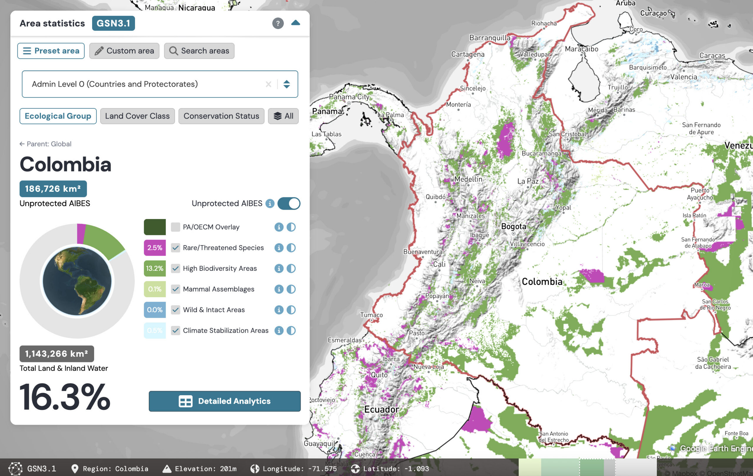
We had a big map when we launched the first version of Global Safety Net. We decided we wanted to put it up on the internet just so people could play around with the data and zoom in and see where things were. The first layer was magenta, and those are areas of particular importance for rare, threatened, or range-restricted species.
Global Safety Net 2 came out when we published another important paper called “Conservation Imperatives.” We really wanted to look at specific regions, and we started this new paper on the most important priorities for conserving these threatened species. We found that much of the land that was shown to be critically important had long been converted to agriculture or some other use. We would not consider those converted parking lots when we’re thinking about 30×30 in the convention. They once were areas for rare species, but they aren’t now. So we tried out a process to remove those areas. We tried to go to a finer scale, at 300-meter [1,000-ft] resolution, and found that, in some places, more than half of the rare species were already gone. They were already converted to human use. But GSN2 was based on a product that the European Space Agency put out, and they terminated it that year.
Mongabay: How did the current version come to be?
Karl Burkart: For GSN3, we actually started from scratch and went down to a 90-meter [300-ft] resolution, which is essentially 100 times more accurate and higher resolution than the original version. That was in partnership with the science team at The Nature Conservancy, who had looked at the history of human modification and used that as a proxy to deductively remove areas that we are pretty sure have been converted to human use.
On a satellite image, sometimes it’s hard to tell the difference. But by going underneath the canopy and looking at the chronology of roads, mining, urban development, and agricultural development and expansion, you’re able to put a picture together from the other way down. So we were looking at the ecology from up; they’re looking at human history. We met in the middle.
It’s a novel method, and it’s higher resolution and much more accurate. What it does is it attempts to estimate this in a consistent way globally. It is very hard to do, but we need to do that for the biodiversity convention. So it creates that estimate of an area that’s very likely to be important for biodiversity and ecosystem services.
We can revisit it annually, too, which is what everyone wants to know. How is it changing in Kenya versus Argentina? How are countries increasing or decreasing their natural areas? Are they protecting more? Are they protecting less? It gives us a way to universally look at the whole world together across many different ecosystem types in a uniform way.
Mongabay: For someone looking at the platform, what would they see?
Karl Burkart: So there are three views, like I said. There’s ecology; there’s land classes; the third view is conservation. How much of this land is conserved, and how is it conserved? Is it strictly protected? Is it regularly protected? Is it OECM, which is “other effective conservation measure,” a new type that’s a bit more like sustainable management. It’s where you can have an area near a timber forest that’s also a reserved forest, for example.
We created two new classes. One is called a documented conservation area. So these are areas that have not been listed in the official U.N. database but are providing very important conservation functions. In many countries, some of the best areas are not in the official registry. They’re unofficial. Sometimes they’re community-led, sometimes they’re private land. So we’re documenting those as well.

We also really want to raise visibility of the role of Indigenous and traditional territories. Indigenous people have long wanted their own designation for the way that they conserve land that’s different from either a protected area or an OECM. Our data reinforces that some of the best-conserved areas in the world are just in Indigenous territories and are not designated yet as any type. So in our new system, we count those as equivalent to a protected area. That is based on research that shows, plus or minus, that traditional Indigenous land is largely as effective as regular government-protected areas. So that’s shown as purple in the maps.
So you can get the whole picture. We can look at one ecoregion and get answers to many questions. How much of it is still intact? How much of it is conserved by various methodologies, including traditional Indigenous governance?
Mongabay: What stood out to you in terms of the data? If you were to highlight two or three things, what would they be?
Karl Burkart: We were surprised by how much land that didn’t meet our criteria of “important” were found inside protected areas. It’s not to say that the land isn’t valuable. We had assumed in Global Safety Net 1 and 2 that a protected area meets those criteria of highly important habitats. In this version, we separated the two processes. So we first looked at all of the land-mapping efforts, and then secondarily we looked at the conservation efforts. So that was surprising because we thought there would be much more of what appears to be important inside of protected areas.
Then there’s a positive thing we found. If you zoomed out, it might look like there’s not much there, especially in Europe. The white areas are areas that we would consider not particularly important. So when you look at Europe, it looks white. It looks mostly empty, like there is no biodiversity there. But of course, we know that in Europe there’s a big biodiversity effort. And so, when you zoom in, you do see these little pockets of areas and those are everywhere. So I think that is one thing: even though we don’t have large areas of biodiversity everywhere, we always have some biodiversity areas.
It was reassuring to see that there are these pockets. We would call those, in scientific terms, microrefugia. Microrefugia are little pockets where development just didn’t happen for one reason or another. They’re little safe havens. What gets very interesting about that is you can think about using those to connect larger refugia together. And that’s something we really want to explore in the future. Now that we have this map, you can actually run AI processes to explore connectivity scenarios. You can get the species in the small refugia to connect somehow to the larger refugia.
Mongabay: How do you hope this data will be used in the future for protection and conservation of land and biodiversity?
Karl Burkart: We were really happy that the data was ready in advance of global stocktaking which was launched at the U.N. in September. It was a high-level event to look at the global state of conservation on land and oceans. They were able to use our data because it gives you that global perspective. So stocktaking is one application, I would say.
Until Global Safety Net, there really was no watchdog or independent, third-party nonprofit. We’re not connected to any country. We don’t have an agenda other than wanting to save biodiversity and ecosystem services. We’re very neutral. So I think having that neutral observer is important.
In the climate convention as well, countries are all reporting their carbon targets and their carbon emissions, and then there are third-party systems that double-check if that’s correct. So this is kind of beginning to be something similar for the biodiversity convention, where we have this global, neutral observer. So I think it’s important for that: keeping everyone on the same page and keeping everyone honest.
The other application, of course, is conservation planning. I’d say the other big use that we’re seeing now is philanthropy. We’ve had philanthropy groups come to us and say, “I have $10 million. Where should I spend my money?” Depending on what they think is the most important, we actually use this data to create very specific lists of priority landscapes that seem to be most in need of conservation funding.
The horizon is corporate accountability. We actually could use our statistics to find the ecoregions that are least protected and most degraded. So we could make a list of where to focus and where you should avoid. So that’s important information for where there are corporate footprints. So that’s something we’re exploring now.
Banner image: Mushrooms growing in a forest. Image by iggii via Unsplash.
Abhishyant Kidangoor is a staff writer at Mongabay. Find him on 𝕏 @AbhishyantPK.
Citations:
Dinerstein, E., Vynne, C., Sala, E., Joshi, A. R., Fernando, S., Lovejoy, T. E., … Wikramanayake, E. (2019). A global deal for nature: Guiding principles, milestones, and targets. Science Advances, 5(4). doi:
Dinerstein, E., Joshi, A. R., Hahn, N. R., Lee, A. T. L., Vynne, C., Burkart, K., … Zolli, A. (2024). Conservation imperatives: Securing the last unprotected terrestrial sites harboring irreplaceable biodiversity. Frontiers in Science, 2, 1349350. doi:10.3389/fsci.2024.1349350
Cite this article
Abhishyant Kidangoor (2026). How much nature is left? Interview with Nature Data Lab’s Karl Burkart. Mongabay Conservation news. DOI: https://doi.org/10.66709/news-332051

