


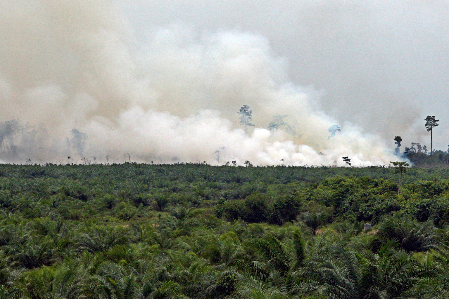
- A new satellite fire-monitoring platform, FireWatch, had detected more than 96,000 hotspots across Indonesia as of July 27, 2026.
- The total exceeds that recorded at the same point in any previous year monitored by FireWatch, even though Indonesia has not yet reached the months when wildfires typically intensify.
- FireWatch estimates that approximately 103,000 hectares (255,000 acres) of land burned nationwide during the first half of 2026, raising concerns as forecasters warn that a strong El Niño could further increase fire risk.
JAKARTA — Indonesia has recorded more fire hotspot activity by late July 2026 than at the same point in any previous year, including during the devastating fire seasons of 2019 and 2023, according to new data.
Data from FireWatch, a new satellite monitoring platform developed by the forest monitoring platform Nusantara Atlas, offers the clearest picture yet of where the country is burning, say scientists. It has raised fresh concerns as Indonesia heads into the months of the year when wildfires historically intensify.
As of July 27, FireWatch detected more than 96,000 fire hotspots across Indonesia — more than at the same point in any previous year monitored by the platform. By comparison, about 88,000 hotspots had been detected by late July 2019 and roughly 58,000 during the same period in 2023.
Those two years produced Indonesia’s most destructive fire seasons in the past 10 years, burning more than 2.6 million hectares (6.4 million acres) and 1.7 million hectares (4.2 million acres), respectively, according to data from FireWatch.
FireWatch estimates that approximately 103,000 hectares (255,000 acres) burned nationwide during the first half of 2026.

While that remains far below the area burned in 2019, Indonesia has yet to enter the period when fire activity historically accelerates. Burning typically increases in August before peaking in September and October.
The unusually high hotspot activity in 2026 comes as forecasters warn that a strong El Niño is developing.
Indonesia’s Meteorology, Climatology and Geophysics Agency (BMKG) says dry conditions have continued to intensify across much of the country. By the second 10-day period of July, nearly 93% of Indonesia had recorded low rainfall, while almost 73% of the country’s seasonal climate zones had entered the dry season.
BMKG warns that strengthening El Niño conditions could further suppress rainfall, increase drought, expand hotspots and raise the risk of forest and land fires, particularly in highly flammable landscapes such as peatlands.
The warning is echoed by independent climate researchers.
New analysis by Berkeley Earth climate scientist Zeke Hausfather, based on forecasts from 14 climate models through July, estimates there is a 90% chance the El Niño now developing in the tropical Pacific Ocean will become the strongest in roughly 150 years of observations, exceeding the record-breaking 2015-16 event.
“It looks like this year’s El Niño is not only very likely to be the strongest event since reliable records began — it may end up the strongest by a truly mind-blowing margin,” Hausfather writes.
Against that backdrop, the current hotspot surge should be viewed as an early warning rather than the peak of Indonesia’s fire season, says David Gaveau, founder of TheTreeMap, the technology consultancy which operates Nusantara Atlas and FireWatch.

FireWatch’s new data
FireWatch’s estimate of 103,000 hectares (255,000 acres) burned during the first half of 2026 is based not only on active fire detections, but also on monthly maps showing the area actually burned — a capability its developers say marks a significant advance in how Indonesia monitors fires.
Hotspots remain one of Indonesia’s primary tools for detecting active fires and supporting emergency response.
However, hotspots do not reveal how much land has ultimately burned, as a single hotspot can represent a small blaze or a much larger fire.
Burned-area maps, by contrast, estimate the full extent of land affected after the flames have passed, providing a better basis for measuring environmental damage, estimating carbon emissions and planning post-fire restoration.
Indonesia’s technical guidelines for burned-area mapping identify these among the primary purposes of estimating burned area. The country already publishes official burned-area estimates through the Ministry of Forestry’s SIPONGI platform.
Under the technical guidelines, which were issued in 2018, analysts estimate burned areas by manually interpreting before-and-after satellite imagery, supported by hotspot detections, field reports and other spatial data. The process requires analysts to visually delineate burned scars on land before calculating their extent.
FireWatch uses a different approach. Rather than relying on manual interpretation, it uses a machine-learning algorithm to automatically detect burned areas in satellite imagery before producing monthly burned-area maps.
According to Gaveau, the automated workflow allows burned areas to be mapped more quickly and consistently, while also enabling users to analyze fires within specific company land concessions, peatland hydrological or water-storage units, protected areas and administrative boundaries.
The interactive platform allows users to zoom from a national overview to individual districts or concessions, compare monthly and cumulative burned areas, and download the datasets. Gaveau says these capabilities make it easier for researchers, journalists, companies and government agencies to identify where fires occurred and who may be responsible for managing the affected land.
The platform is built on a peer-reviewed methodology published earlier this year in the journal PLOS ONE and uses Google Earth Engine to process the monthly maps.
The system was designed to produce conservative estimates by prioritizing only “high-confidence” detections of burned areas derived from Sentinel-2 satellite imagery, which has a much finer spatial resolution than imagery used in many existing global burned-area datasets.
With a reported user accuracy of 98.7%, roughly 98 out of every 100 mapped burn scars correspond to actual burned areas, according to Gaveau.
The higher-resolution imagery also enables FireWatch to detect many smaller burned patches that coarser, global burned-area detection products often miss, providing a more complete picture of fire activity across Indonesia, he says.
The distinction matters because burned area — not hotspot counts — is the metric used to assess ecological damage, estimate greenhouse gas emissions, evaluate impact on biodiversity and calculate economic losses from fire.
Indonesia’s peatland fires also have consequences far beyond its borders.
Tropical peatlands store enormous quantities of carbon accumulated over thousands of years. When they burn, they release large amounts of carbon dioxide and other greenhouse gases into the atmosphere, contributing to global climate change. Peatland fires also produce transboundary haze, fire-related air pollution that crosses borders, that can affect air quality across Southeast Asia.

Early warning
FireWatch’s data is already being reflected in some of Indonesia’s most ecologically important peatland landscapes.
Separate hotspot data compiled by peatland watchdog group Pantau Gambut show that more than 28,000 hotspots were detected within Indonesia’s peat hydrological units (Kesatuan Hidrologis Gambut or KHGs) during the first half of 2026.
Nearly two-thirds occurred within peatlands designated as protected ecosystem functions, with Riau in Sumatra and West Kalimantan in Borneo accounting for the largest share.
The figures suggest that despite years of restoration efforts, fire activity remains concentrated in some of Indonesia’s most carbon-rich and environmentally sensitive landscapes.
One of the most alarming examples comes from the Tripa peat swamp, part of the globally important Leuser Ecosystem, much of which is in Sumatra’s Aceh province.
Between May 27 and June 5, Pantau Gambut and the conservation organization HAkA detected 395 hotspots inside the oil palm concession of palm oil company PT Gelora Sawita Makmur, using data from NASA’s VIIRS and MODIS satellites.
Their analysis of satellite imagery from PlanetScope taken on June 9 and June 13 estimated that approximately 605 hectares (1,500 acres) of peatland had burned.
A joint field team comprised of HAkA, Aceh’s Forest Management Unit (KPH) and several journalists later visited the site to verify the satellite observations.
The fire’s spatial pattern and conditions observed in the field strongly indicate that the burning was associated with land clearing, HAkA says.
HAkA says it could not determine the cause of the fire and that further investigation by authorities is needed.
The fire poses a significant threat to the Tripa peat swamp, one of the last remaining peat swamp forests within the Leuser Ecosystem and a globally important habitat for the critically endangered Sumatran orangutan (Pongo abelii).
Pantau Gambut says the fires are part of a broader trend. Between January and May 2026, the organization detected 528 hotspots in Nagan Raya district where much of the Tripa peat swamp is located — 43 times more than during the same period last year, when only 12 hotspots were recorded.
According to Pantau Gambut, the increase in detected hotspots strengthens concerns that continued peat drainage through canal construction for land conversion for monoculture plantations remain among the principal drivers of recurring fires in peat ecosystems.
“The Tripa peat swamp is paying the price for years of failed prevention efforts,”HAkA legal and advocacy manager Muhammad Fahmi says in a statement. “If this cycle of fires is allowed to continue, the damage will no longer be limited to the loss of land — it will mean the loss of ecosystem functions that sustain the people of Aceh.”

Fire in South Papua
Tripa is not the only landscape showing signs of increasing fire activity.
Nearly 7,000 kilometers (43,000 miles) to the east, satellite monitoring also detects growing numbers of hotspots in South Papua, where large-scale agricultural development has transformed vast areas of lowland forest and wetlands.
Gaveau says FireWatch has revealed several clusters of burned areas and hotspots occurring alongside newly constructed roads built to support the government’s food estate program.
While the spatial overlap alone does not establish that the road construction or food estate development caused the fires, it highlights locations that warrant closer investigation, he adds.
Pantau Gambut, meanwhile, recorded 1,310 hotspots across the province’s peat hydrological units during the first half of 2026. Its findings coincide with the expansion of government-backed food and energy projects across South Papua, although the hotspot data alone do not establish that those projects caused the fires.
Putra Saptian, a campaigner with Pantau Gambut, says the concentration of hotspots in peat landscapes highlights the need to assess ecological and hydrological risks before converting peatlands for development.
According to Putra, El Niño is amplifying, rather than causing, this year’s fire risk.
Prolonged dry conditions become particularly dangerous when peatlands have already been drained or otherwise degraded, making them less able to retain water and more susceptible to burning, he adds.
The concerns extend beyond peatland advocates. Indonesia’s largest environmental group, Walhi, reports that it detected 399 hotspots within concessions associated with National Strategic Projects (PSNs) between July 1 and July 9.
According to Walhi, 245 hotspots were located within food estate areas, large-scale agricultural areas.
The organization says the findings suggest that large-scale land-use change deserves closer scrutiny as Indonesia enters its most fire-prone months of the year.
“Recurring fires in landscapes like these cannot simply be viewed as natural events,” Walhi campaign manager Uli Arta Siagian says in a statement. “They must instead be understood as part of the massive transformation of the landscape itself.”

Government steps up fire preparedness
With Indonesia entering the most fire-prone months of the year, the government has ordered local authorities and concession holders to strengthen efforts to prevent forest and land fires, particularly across peatlands.
Environment Minister Jumhur Hidayat has said the ministry’s strategy focuses on keeping peatlands wet, preventing them from drying to the point where they become highly combustible.
“Peatlands are not just land that needs to be protected from fire,” Jumhur said during a recent national meeting on peatland fire preparedness in Jakarta. “They are an important part of our environmental ecosystem.”
The ministry has instructed concession holders to reinforce peatland “rewetting” measures by constructing and maintaining canal blocks that retain water within peat landscapes, and to build water reservoirs to support firefighting during the dry season.
According to the ministry, approximately 4.15 million hectares (10.3 million acres) of peatlands managed by 314 companies are now equipped with nearly 35,000 canal blocks. Outside concessions, including community lands and forest areas, another 8,857 canal blocks have been built, although officials estimate that more than 17,000 additional structures are still needed to restore peatland hydrology nationwide.
The ministry has also warned that companies found responsible for fires inside their concessions could face administrative, civil or criminal sanctions under Indonesia’s environmental laws.
Some environmental groups argue that reducing fire risk also requires addressing the financial incentives that continue to support the conversion of forest land to commercial use.

Financing fires
Some Indonesian NGOs, together with NGOs in several other countries, are calling out the banking sector for their roles in financing companies that drive deforestation and forest fires.
Data from Forests & Finance show that between 2016 and 2025, global financial institutions provided at least $429 billion in financing to industries, such as timber, soy, rubber, pulp and paper, palm oil and cattle, that are major drivers of deforestation and contribute to an increasing risk of forest and peatland fires..
The scale of this financing demonstrates that the financial sector plays an important role in either driving or preventing environmental damage through its lending policies. That’s why the NGOs recently sent an open letter to 190 financial institutions in multiple countries, urging them to strengthen no-deforestation, no-peat and no-exploitation (NDPE) policies and to stop financing companies linked to forest and land fires.
“El Niño cannot be prevented, but its impacts can be minimized if the financial sector stops financing business models that destroy forests,” says Linda Rosalina, executive director of NGO TuK INDONESIA, in a press release. “The financial sector therefore cannot be treated as a neutral actor in addressing the climate crisis.”
Adam Putra Firdaus, acting head of the forestry and biodiversity division at the Indonesian Center for Environmental Law (ICEL), says financial actors should also be held accountable if they continue financing those responsible for forest and peatland destruction.
“There should be no financial gain built upon financing the destruction of forests and peatlands that worsens the climate crisis,” he says.
Whether 2026 ultimately becomes a fire season comparable to 2019 or 2023 remains uncertain.
For now, both FireWatch’s data and official monitoring show that Indonesia is entering the most dangerous period of the dry season with unusually high early fire activity already recorded across several regions.
For Gaveau, that makes the latest data less a prediction than a warning: “The current hotspot signal is an early warning. We’re not yet at the peak.”
Citations:
Gaveau, D. L., Descals, A., & Salim, M. A. (2026). Nationwide monthly burned area monitoring in Indonesia using Sentinel-2. PLOS One, 21(4), e0331831. doi:10.1371/journal.pone.0331831
Banner image: Smoke, allegedly from a fire used for land clearing, billows at an oil palm plantation at a peat swamp in Aceh province, Indonesia, in 2012. Image by Dita Alangkara/CIFOR via Flickr (CC BY-NC-ND 2.0).
FEEDBACK: Use this formto send a message to the author of this post. If you want to post a public comment, you can do that at the bottom of the page.
Cite this article
Hans Nicholas Jong, Irfan Maulana (2026). Indonesia shows elevated fire hotspot activity in 2026 as super El Niño threat looms. Mongabay Conservation news. DOI: https://doi.org/10.66709/news-324772

