

Close Menu
NCIJ Network NCIJ Network
    What's Hot

    Philadelphia Juggles Short-Term Budget Plans and Long-Term Climate Goals

    August 6, 2026

    UK to get extreme environment center for subsea technology testing

    August 6, 2026

    Colombia’s de la Espriella Can Seek Security Through Rural Development

    August 6, 2026
    Facebook X (Twitter) Instagram
    Trending
    • Philadelphia Juggles Short-Term Budget Plans and Long-Term Climate Goals
    • UK to get extreme environment center for subsea technology testing
    • Colombia’s de la Espriella Can Seek Security Through Rural Development
    • Investigating video allegedly showing white woman calling police on Black family at pool
    • EasyJet agrees to £5.7bn takeover by US firm
    • Spain’s far-left and far-right unite to oppose Morocco’s bid to co-host 2030 World Cup – POLITICO
    • Edgy Vanity Plates Test Limits of Free Speech
    • Burnham ‘personally intervened’ over possible early prison release of grooming gang perpetrators | Prisons and probation
    • About
      • Our Team
      • Editorial Policy
      • Editorial Independence
      • International Support
    • Trust & Standards
      • AI Usage Policy
      • Conflict of Interest Policy
      • Corrections Policy
      • Ethics Policy
      • Fact-Checking Policy
      • Source Protection
    • Get Involved
      • Guide for Sources
      • Support Independent Journalism
    • Legal
      • Cookie Policy
      • Privacy Policy
      • Terms of Use
    Facebook X (Twitter) Instagram
    NCIJ Network NCIJ Network
    Thursday, August 6
    • Home
    • World
    • Ai
    • Business
    • Politics
    • Health
    • Crypto
    • Science
    • Technology
    • Cybersecurity
    • Defense & Security
    • Economy
    • Energy
    • Europe
    • More
      • Fact Check
      • Investigations
      • Opinion & Analysis
      • Environment
    NCIJ Network NCIJ Network
    Home»Science

    How the Tide Turns at the Mouth of the Elbe

    NCIJ NETWNCIJ NETWORKBy NCIJ NETWNCIJ NETWORKAugust 6, 2026 Science No Comments4 Mins Read
    Share
    Facebook Twitter LinkedIn Pinterest Email

    One of the major rivers of Europe, the Elbe flows more than 1,000 kilometers (600 miles) across the continent before reaching the North Sea. At its mouth, the low-lying landscape is continually reshaped by the rise and fall of the tides. These dynamic tidal flats are a boon to biodiversity while sometimes posing challenges for those navigating its waters and for communities living along its shores.

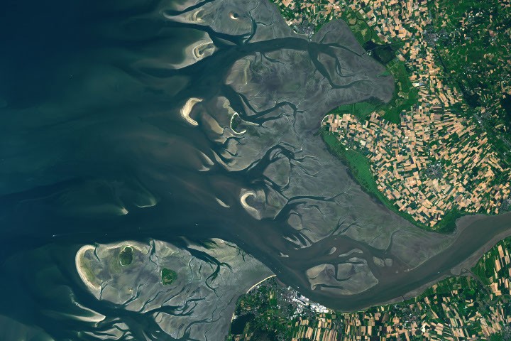
    The images above illustrate how the area changes with the tides. They were acquired on August 15, 2025, at low tide (left) and on May 11, 2025, at high tide (right) with the OLI (Operational Land Imager) on Landsat 9. The mean tidal range at Cuxhaven is 2.9 meters (9.5 feet), which is considered intermediate, or mesotidal. The tides are also asymmetrical, meaning the flood period is shorter than the ebb. This causes the incoming current to run faster and typically carry more sediment up the 140-kilometer-long (87-mile-long) estuary than it does out.

    The low tide exposes complex channels, sandbars, and mudflats around the river mouth. This wide zone of coastal wetlands is part of the Wadden Sea, which stretches from the Netherlands to southern Denmark and represents the largest continuous system of intertidal sand and mud flats in the world. Its habitats serve as important staging, molting, and wintering grounds for migratory birds, with more than 10 million passing through every year.

    A channel cuts through these natural features near the river’s mouth, allowing ships to reach Cuxhaven and Hamburg—the third-largest container port in the European Union—farther upriver. Dredging is required to remove accumulated sediment in the channel, and some ships can only pass through when the tide is high enough. The Elbe’s mouth also provides access to the Kiel Canal, which connects the North Sea and Baltic Sea and is the world’s busiest human-made waterway navigable by seagoing ships. 

    At high tide (right), only a handful of small islands and sandbars remain above the waves. One of these islands, Neuwerk, is a tranquil tourist destination that is home to a few dozen inhabitants and the oldest building on the German coast. A brick tower, completed in 1310 and later converted to a lighthouse, was built to protect shipping on the Elbe from pirates and wreckers.

    These images show normal tidal variation in the area, but storms can push water levels much higher than a typical high tide. The highest water level measured at Cuxhaven—5.1 meters (16.7 feet) above Europe’s official sea level reference—occurred on January 3, 1976, when a fast-moving storm swept across the North Sea and slammed the coast with high winds. Researchers who reconstructed historical storms noted that the storm surge was worsened by its timing relative to the tide. The strongest winds arrived around low tide, preventing water that had propagated upstream at high tide from flowing back out to sea and causing further inundation inland.

    Scientists study past extreme events like this to better understand how future storms might affect low-lying coastal areas and how flood protection could be improved. Flooding risks can be exacerbated by rising sea levels, which at Cuxhaven have trended upward by 2.12 millimeters per year, or 0.70 feet per century.

    Two new Earth-observing satellites are making it possible to measure water levels in coastal areas in greater detail. The dual-band radar on the NISAR (NASA-ISRO Synthetic Aperture Radar) satellite is expected to track long-term phenomena such as sea level changes, as well as to map flood inundation and other ephemeral events. In addition, early data from NASA’s SWOT (Surface Water and Ocean Topography) satellite has demonstrated the potential to accurately measure water levels around complex coastlines and to improve tidal models.

    NASA Earth Observatory images by Lauren Dauphin, using Landsat data from the U.S. Geological Survey. Photo by Thomas Gölles. Story by Lindsey Doermann. 
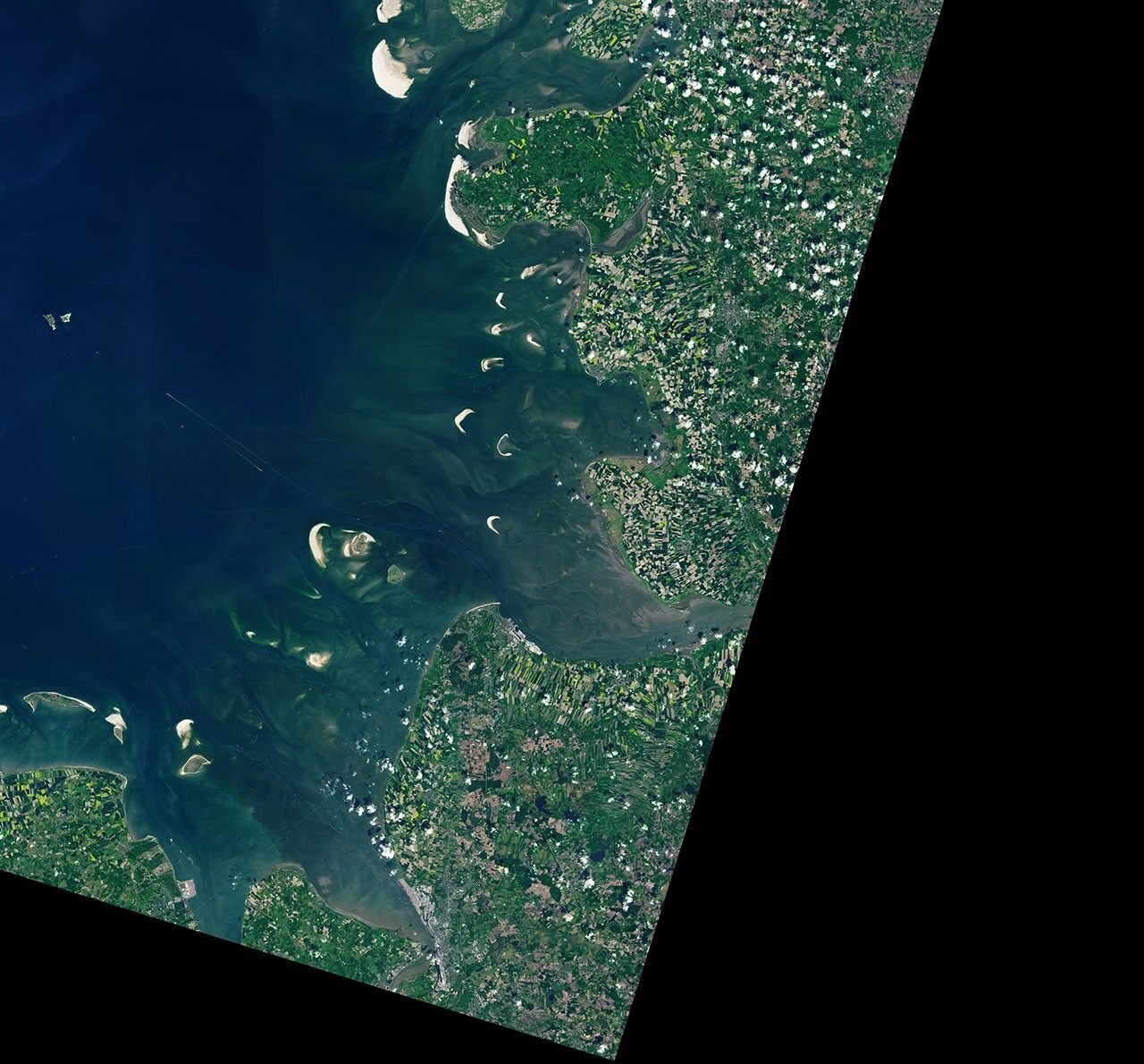
    The Elbe river in Germany into the North Sea on the left side of the image. At high tide, a handful of small islands and crescent-shaped sandbars remain exposed above the water level near shore. Ships are visible as small, bright specks on the water.

    Elbe Mouth tide turns
    NCIJ NETWNCIJ NETWORK
    • Website

    Keep Reading

    Heat-trapping asteroid dust may have incinerated the dinosaurs within hours  

    A star’s violent death exposed a hidden supermassive black hole

    Major study challenges long-held fears about acetaminophen and ibuprofen use in babies

    Majority of England’s rivers and lakes fail pollution review

    The Paradox of Lençóis Maranhenses National Park

    THC medication made PTSD nightmares disappear for more than a third of patients

    Add A Comment
    Leave A Reply Cancel Reply

    Editors Picks

    Philadelphia Juggles Short-Term Budget Plans and Long-Term Climate Goals

    August 6, 2026

    UK to get extreme environment center for subsea technology testing

    August 6, 2026

    Colombia’s de la Espriella Can Seek Security Through Rural Development

    August 6, 2026

    Investigating video allegedly showing white woman calling police on Black family at pool

    August 6, 2026
    Latest Posts

    Bitcoin treasury company erases 7.7M shares after selling 177 BTC

    July 24, 2026

    New Dolphin X malware uses AI to rank high-value targets

    July 24, 2026

    An FDA Panel Just Endorsed These Unproven Peptides

    July 24, 2026

    Subscribe to News

    Get the latest sports news from NewsSite about world, sports and politics.

    NCIJ Network is an independent digital news platform delivering trusted investigative journalism, European and global news, in-depth analysis, and fact-based reporting with accuracy, transparency, and integrity.

    Facebook X (Twitter) Instagram Pinterest YouTube

    Philadelphia Juggles Short-Term Budget Plans and Long-Term Climate Goals

    August 6, 2026

    UK to get extreme environment center for subsea technology testing

    August 6, 2026

    Colombia’s de la Espriella Can Seek Security Through Rural Development

    August 6, 2026

    Subscribe to Updates

    Get the latest creative news from FooBar about art, design and business.

    Type above and press Enter to search. Press Esc to cancel.