


- In late 2025, extreme rainfall associated with Cyclone Senyar wiped out swaths of North Sumatra’s Batang Toru ecosystem, home to the largest known population of Tapanuli orangutans.
- Nearly a year later, there are is still no coordinated recovery strategy for the critically endangered ape, and its habitat faces multiple threats.
- Satellite footage from June this year shows new ground disturbances in the area; plans to expand a gold mine are proceeding even as an environmental audit of the mine is underway; and meteorologists warn that Indonesia faces an unusually severe fire season.
JAKARTA — Nearly a year after what scientists describe as one of the most severe ecological shocks ever documented for the world’s rarest great ape species, there is still no coordinated recovery strategy for Tapanuli orangutans, even as mining resumes, future development plans remain active, and a strong El Niño introduces a new threat.
That broader concern over the survival of the critically endangered Tapanuli orangutan (Pongo tapanuliensis) has been sharpened by recent satellite imagery showing fresh ground disturbances inside the concession for Indonesia’s Martabe gold mine, which overlaps with the ape’s habitat.
Disputed disturbances
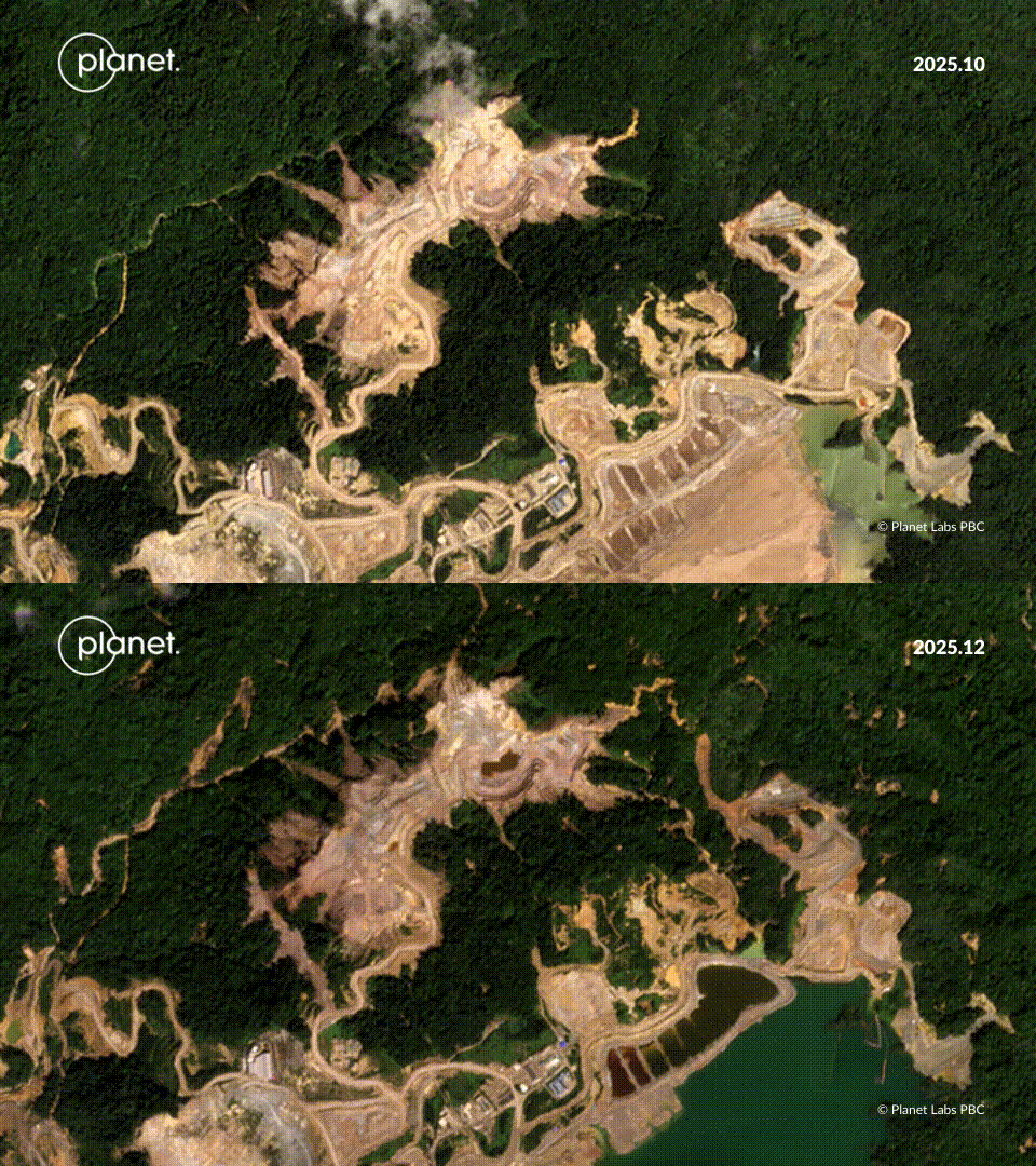
The disturbances appeared as swaths of treeless and disturbed earth between June 13 and June 23 on steep rainforest hills around the Ramba Joring pit in Batang Toru, North Sumatra province, according to Planet satellite imagery reviewed by Mongabay. The area is part of an ecosystem that supports the largest known population of the Tapanuli orangutan. Researchers estimate that 716 Tapanuli orangutans remain in Batang Toru, with the population split across three increasingly fragmented subpopulations, leaving the species with little demographic margin for additional losses.

Mighty Earth, a U.S.-based environmental organization, describes the features as landslides associated with mine development. Agincourt Resources, which operates the Martabe mine, disputes that characterization, saying the June disturbance resulted from material movement following blasting carried out within its planned operational area. The blasting, the company said, was planned with consideration of topography, geotechnical conditions, and slope stability.

The dispute comes less than a year after extreme rainfall associated with Cyclone Senyar triggered widespread landslides across the Batang Toru landscape. A recent scientific study estimated that the November-December 2025 disaster may have killed around 58 Tapanuli orangutans and damaged more than 8,300 hectares (20,500 acres) of intact forest in the western block of the ecosystem.
The June disturbances are located near an access road developed for the proposed 50-hectare (124-acre) Tor Ulu Ala (TUA) pit, north of Martabe’s existing mining footprint. The company says no construction took place on the access road to its proposed TUA pit in 2026, a chronology supported by satellite imagery reviewed by Mongabay.
Development plans show different areas scheduled for disturbance at different stages through the mine’s life. Mighty Earth’s analysis of the company’s map indicates that portions of the June disturbance fall outside the areas planned for disturbance through 2030.

Mighty Earth campaign director Phil Aikman said the fact that construction of the access road stopped in late 2025 did not necessarily rule out a connection between the earlier earthworks and later ground movement. He said earthworks on steep hillsides could have contributed to subsequent instability.
Indonesia’s Ministry of Environment also declined to say whether authorities had investigated the June disturbance. Deputy Minister Sigit Reliantoro told Mongabay to check with law enforcement when asked whether the ministry was aware of the disturbance.

An ecosystem under pressure
Regardless of the precise cause of the ground changes in June, conservation scientists say the larger question is what the repeated disturbances mean for an already damaged orangutan habitat.
“The question isn’t simply what caused these scars,” Aikman said. “The bigger question is whether the habitat remains viable after the cyclone and continuing development.”
That question remains unresolved seven months after Cyclone Senyar struck Batang Toru.
A recent satellite-based analysis estimated that the storm destroyed more than 8,300 hectares of intact forest in the western block of the Batang Toru ecosystem, where the Martabe mine is located and where the largest known population of Tapanuli orangutans lives.
By cross-referencing areas hit by the storm and known orangutan habitat, the study estimated that landslides triggered by the storm may have killed around 58 orangutans.

The estimate is particularly concerning because researchers say the species’ long-term survival doesn’t allow for an annual mortality rate higher than 1%. The estimated mortality from the study was more than seven times that threshold.
Conservation biologist Erik Meijaard, one of the study’s authors, said he suspects the June disturbances may represent secondary landslides resulting from slopes destabilized during the November 2025 disaster, although he cautioned that no quantitative analysis has yet been carried out.
“I suspect that these are secondary landslides, and these secondary effects are likely to occur throughout the region because soils are left unstable because of previous landslides,” he told Mongabay.
High tree mortality around existing landslides could further destabilize slopes over time and increase the risk of additional habitat degradation, Meijaard added.
For both Meijaard and Aikman, the central conservation concern is not simply whether individual orangutans survived the cyclone, but whether the western Batang Toru landscape can continue supporting a viable population of the apes in the face of cumulative impacts from the 2025 disaster, ongoing infrastructure development, and future disturbances.
“The west block was the epicenter of the Tapanuli orangutan population, and now we don’t actually really know what the population health is,” Aikman said.
Some orangutans remain unaccounted for
Agincourt disputes the study’s estimate of orangutan mortality, saying its own post-disaster monitoring found no evidence of orangutan deaths in the areas it surveyed.
The company said field teams confirmed the survival of previously identified individual orangutans and recorded three previously undocumented individuals during post-disaster monitoring. But Agincourt also said its teams had surveyed only about 63% of its Martabe Preservation Area because the remaining 37% is inaccessible due to steep terrain and safety risks.
That means some previously monitored orangutans have not yet been reconfirmed.
Agincourt also did not provide Mongabay with the baseline number of individual orangutans it had been monitoring before the disaster.
The company said its monitoring had found no significant effect from the June disturbance on Tapanuli orangutans or their habitat, adding that no orangutans were found in the disturbed area.
Aikman questioned what could be inferred from that finding, noting that the absence of orangutans in an area after it has been disturbed does not establish whether the animals had previously used the area or whether the disturbance affected their habitat.

Audit continues as mine resumes operations
The uncertainty comes as Agincourt has resumed mining operations while an environmental audit ordered by the Ministry of Environment remains underway.
The audit was ordered after Cyclone Senyar. At the time, authorities filed civil lawsuits against six companies, including Agincourt, over allegations that their operations had exacerbated the impacts of the storm, and announced a series of administrative sanctions requiring environmental audits. The government initially considered revoking Agincourt’s mining permit, but later allowed the company to resume operations after reaching an out-of-court settlement.
The audit, however, has not yet been completed.
Nety Widayati, the environment ministry’s director of impact prevention for business and activities, told Mongabay that the environmental audit and Agincourt’s authority to operate are legally separate processes.
“The environmental approval wasn’t revoked,” she said. “They were simply ordered to undergo an environmental audit.”
According to Nety, this means the company can legally continue operating.
She said the audit is expected to be completed within about a month and will produce recommendations for future environmental management.
Those recommendations could include zoning changes, restrictions on future development, environmental restoration, or requirements to avoid or minimize activities in environmentally sensitive areas, she said.
Nety said the audit is not intended to determine whether a single company caused the November disaster. Instead, she said the ministry views the impacts as cumulative, resulting from multiple activities across the Batang Toru landscape.

Expansion plans remain on the table
Despite the disaster, incomplete post-disaster monitoring and the June ground disturbance, Agincourt says it still intends to develop the TUA pit.
The proposed pit is located immediately north of the existing Martabe mining area in a part of Batang Toru that has been recognized by conservation group Alliance for Zero Extinction (AZE) as a Key Biodiversity Area.
Conservationists have questioned why Agincourt has focused its new exploration in the TUA area and not another part of its 130,252-hectare (321,860-acre) concession.
“This is absolutely the wrong place to be digging for gold,” said Amanda Hurowitz, who coordinates the forest commodities team at Mighty Earth. “And for what? So mountains of gold bullion bars can sit in the vaults of the world’s richest countries.”
Company documents describe the project as essential for extending the mine’s life by five to 10 years and supplying material needed for long-term mine closure. Agincourt has also presented the project as compatible with conservation through biodiversity monitoring, habitat restoration, and a proposed 3,700-hectare (9,140-acre) biodiversity offset project.
The June ground disturbance has apparently not caused Agincourt to abandon or fundamentally redesign the TUA project, with the company telling Mongabay it still plans to develop the pit, with access-road construction scheduled to begin in the second half of 2027 and pit development planned for the end of that year.
There’s also no fundamental changes to its planned design or biodiversity safeguards, Agincourt added.
Separately, Indonesia’s environmental permitting platform shows that Agincourt registered an environmental application on July 9, 2026, for exploration activities associated with the proposed TUA underground mining project. The application had completed the system’s automatic screening process and moved into subsequent stages of review.
The underground mine is separate from the proposed TUA open-pit development, although Agincourt has said the two are intended to proceed in parallel.

A new threat emerges
The pressure on the ecosystem is not limited to landslides and mining.
Unlike an intact rainforest, forests damaged by landslides contain large amounts of dead and drying vegetation that can become fuel during prolonged dry conditions. Loss of canopy cover can also expose the forest floor to higher temperatures and faster drying.
The November-December disaster killed large numbers of trees across parts of Batang Toru. Meijaard warned that the resulting dead and drying vegetation could leave the damaged forest more vulnerable to wildfire.
That concern is heightened by the onset of a strong El Niño, which is already supercharging fires in other parts of Indonesia.
“With a severe El Niño predicted, we are very concerned about droughts and the risk of fires escaping into the landscape already degraded by landslides,” Meijaard said.
Aikman of Mighty Earth expressed similar concerns, saying the combination of landslide damage, continued habitat disturbance, and prolonged drought could place additional pressure on the already fragmented Batang Toru ecosystem.
Indonesia’s weather agency, the BMKG, announced on July 30 that the country had officially entered a strong El Niño phase. It said the phenomenon is expected to further suppress rainfall across much of Indonesia and warned of increasing drought and forest-fire risks during the coming months.
Early indicators suggest the national fire season is already unusually active.
Data from FireWatch, a new satellite monitoring platform developed by the forest monitoring platform Nusantara Atlas, shows that there were more than 637,000 hotspots across Indonesia as of Sept. 17, far higher than during the same time in 2019, which was the worst fire year in the platform’s record.
For Aikman, the concern is not that Batang Toru will necessarily burn, but whether the ecosystem is still healthy enough to prevent burning during the dry season, and to sustain the Tapanuli orangutan habitat.
“We’re at red alert now,” Aikman said.
Citations:
Meijaard, E., Wafiy, M., Ni’Mattulah, S., Dennis, R., Hadisiswoyo, P., Sheil, D., . . . Wich, S. (2026). Extreme rainfall further endangers the world’s rarest great ape. Current Biology, 36(12), 3176-3183.e2. doi:10.1016/j.cub.2026.05.029
Hadi, A. N., Siregar, J. P., Anugrah, N., Kuswanda, W., Boang Manalu, J. H., Nasution, N., . . . Buckley, B. J. W. (2026). Population status of Sumatran and Tapanuli orangutans: A comprehensive assessment 2021-2023. Global Ecology and Conservation, 69, e04302. doi:10.1016/j.gecco.2026.e04302
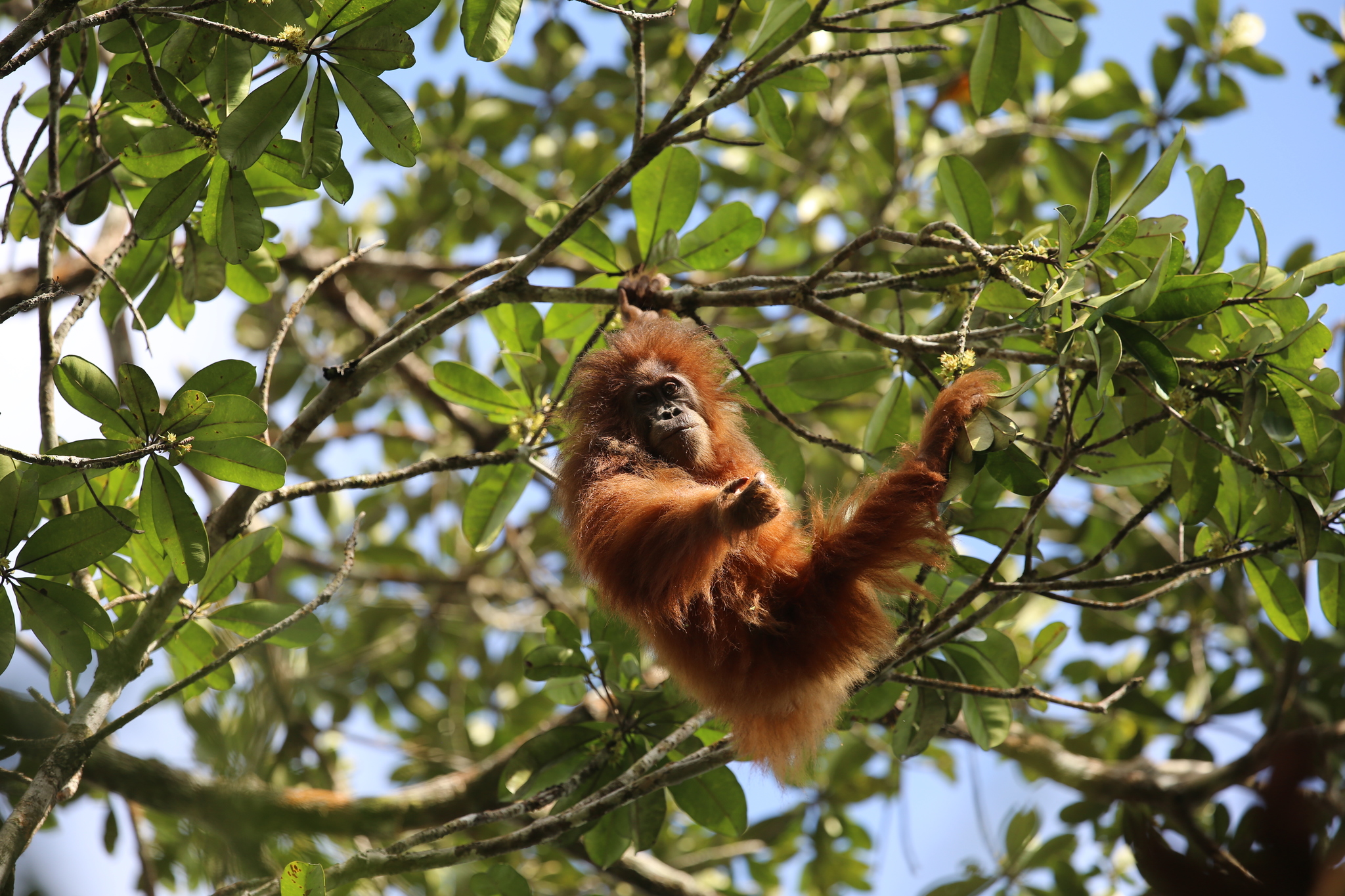
Banner image: A Tapanuli orangutan. Image © Bert Harris via iNaturalist (CC BY-NC 4.0).
FEEDBACK: Use this form to send a message to the author of this post. If you want to post a public comment, you can do that at the bottom of the page.
Cite this article
Hans Nicholas Jong (2026). Tapanuli orangutans face mining, landslides, and fire threats — with no recovery plan. Mongabay Conservation news. DOI: https://doi.org/10.66709/news-330177

